Log in
All resources
Create a design
478 Free Artworks of Old Maps Of Paris
bibliothèque nationale de france
fonds ancely - bibliothèque municipale de toulouse - maps
steel engraving print
bibliothèques de toulouse
raymond bonheur
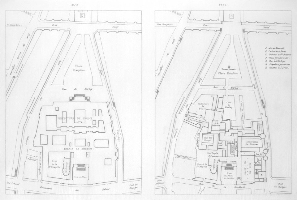
atlas des anciens plans de paris by imprimerie nationale, 1880 from bhvp
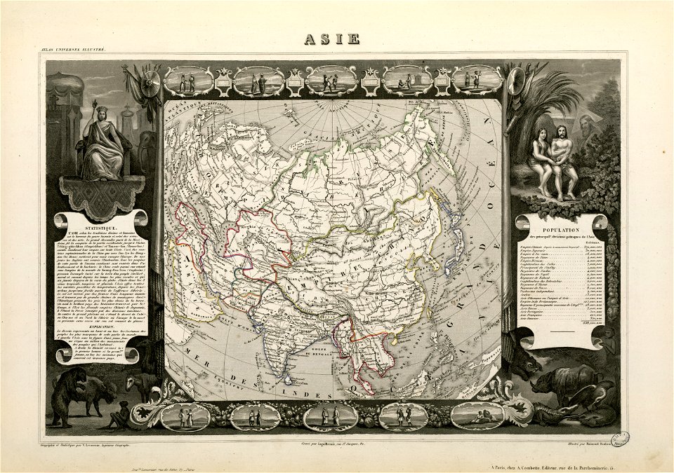
victor levasseur - maps of france
guides joanne
maps of paris from the david rumsey historical map collection
old maps of algiers
old submaps of paris 3e arrondissement
rue du temple (paris)
map of paris by truschet and hoyau - derivatives files
église saint-sulpice on old maps
19th-century maps of greece
pierre françois tardieu
maps of paris from the david rumsey historical map collection
romanticism
turgot map of paris, david rumsey historical map collection – derivative files
église saint-sulpice on old maps
old maps of vermandois
old maps of santerre
maps of paris from bibliothèque nationale de france
maps of paris by braun & hogenberg
maps of paris from bibliothèque nationale de france
dheulland map of paris
historical images of église saint-nicolas-du-chardonnet
map of paris by braun & hogenberg - derivative files
map of paris by braun & hogenberg - derivative files
rue montmartre (paris)
lithographs of paris
floor plans of paris
paris à travers les âges
lithographs of paris
atlas des anciens plans de paris by imprimerie nationale, 1900 from the david rumsey historical map collection
maps of paris from the david rumsey historical map collection
atlas des anciens plans de paris by imprimerie nationale, 1900 from the david rumsey historical map collection
maps of paris from the david rumsey historical map collection
historical images of oratoire du louvre
hôtel du bouchage (paris)
maps by alain manesson-mallet
1683 maps of russia
maps by alain manesson-mallet
description de l'universe
old maps of algiers
maps from gallica
coats of arms of mézières (ardennes)
victor levasseur - maps of france
map of paris by braun & hogenberg - derivative files
rue des archives (paris)
turgot map of paris – derivative files
maison du temple (paris)
atlas des anciens plans de paris by imprimerie nationale, 1880 from bhvp
plan de roussel
atlas des anciens plans de paris by imprimerie nationale, 1880 from bhvp
map of paris by jouvin de rochefort (boutier 112)
old maps of the environments of paris
maps by alexis-hubert jaillot
victor levasseur - maps of the world
old maps of north america
17th-century maps of denmark
old maps of seas
17th-century maps of south asia
maps by alexis-hubert jaillot
plan de dheulland - derivatives files
ruisseau de ménilmontant
paris à travers les âges
lithographs of paris
atlas des anciens plans de paris by imprimerie nationale, 1880 from bhvp
proletarian literature
old submaps of paris 1er arrondissement
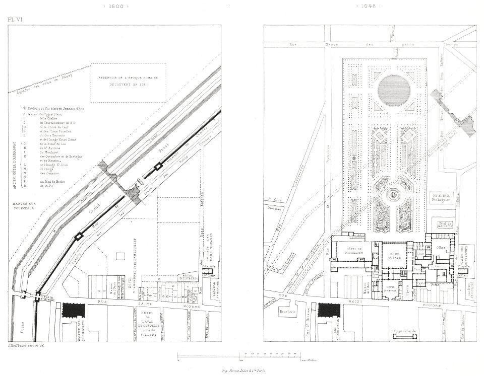
plans of the palais-royal
map of paris by braun & hogenberg - derivative files
le marais
petit atlas pittoresque des 48 quartiers de la ville de paris, bhvp
paris former 4e arrondissement
petit atlas pittoresque des 48 quartiers de la ville de paris, bhvp
paris former 4e arrondissement
maps from gallica
old maps of genoa
atlas des anciens plans de paris by imprimerie nationale, 1880 from bhvp
dheulland map of paris
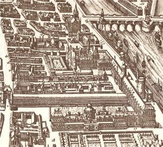
engravings of palais royal by theodor hoffbauer
lithographs of paris
old maps of syracuse
pierre-adrien pâris
atlas des anciens plans de paris by imprimerie nationale, 1880 from bhvp
map of paris by jouvin de rochefort (boutier 112)
atlas des anciens plans de paris by imprimerie nationale, 1880 from bhvp
18th-century maps of paris
atlas des anciens plans de paris by imprimerie nationale, 1880 from bhvp
map of paris by jouvin de rochefort (boutier 112)
algiers in the 19th century
old maps of algiers
maps of paris from the david rumsey historical map collection
1774 in paris
atlas des anciens plans de paris by imprimerie nationale, 1880 from bhvp
maps of paris by braun & hogenberg
plan de la ville et faubourg de paris, divisé en ses 48 sections by mondhare & jean
maps of paris from paris musées
old maps of île saint-louis
maps of paris in the 1740s
merian plan of paris - derivative files
baroque
algiers in the 19th century
old maps of algiers
atlas des anciens plans de paris by imprimerie nationale, 1880 from bhvp
map of paris by françois quesnel
old maps of algiers
maps from gallica
old submaps of paris 5e arrondissement
turgot map of paris – derivative files
plan de paris levé par les ordres du roy, 1900
proletarian literature
maps of paris from bibliothèque nationale de france
plan de roussel
old submaps of paris 2e arrondissement
rue louis-le-grand (paris)
algiers in the 19th century
old maps of algiers
illustrations from découverte de la terre
19th-century maps of cities
lutetia parisiorum urbs, toto orbe celeberrima notissimaque caput regni franciæ by sebastian münster
maps of paris from bibliothèque nationale de france
lutetia parisiorum urbs, toto orbe celeberrima notissimaque caput regni franciæ by sebastian münster
maps of paris from bibliothèque nationale de france
paris depuis charles v jusqu'à charles ix d'après le plan de l'abbaye st-victor
maps of paris from paris musées
coats of arms of rhône
old maps of rhône
maps of brest from bibliothèque nationale de france
maps from gallica
old maps of the republic of genoa
maps of the duchy of milan
algiers in the 19th century
old maps of algiers
old maps of antiparos
old maps of paros
victor levasseur - maps of the world
1854 maps of africa
maps in the british museum
maps by pieter mortier
coats of arms of cities in haute-loire
marquis de lafayette in art
coats of arms of auch
old maps of gers
victor levasseur - maps of france
coats of arms of perpignan
old maps of île de la cité
jean-baptiste scotin
old maps of regions of france
pierre françois tardieu
turgot map of paris – derivative files
hôtel de longueville (louvre)
1777 maps of new york (state)
1777 maps of new jersey
coats of arms of cities in ardèche
victor levasseur - maps of france
coats of arms of orléans
gaspard de coligny
victor levasseur - maps of france
old maps of gironde
pierre terrail de bayard
casimir pierre perier
série 09. paris. hôpitaux et hospices
drawings in musée carnavalet
atlas des anciens plans de paris by imprimerie nationale, 1880 from bhvp
map of paris by françois quesnel
atlas des anciens plans de paris by imprimerie nationale, 1880 from bhvp
map of paris by françois quesnel
algiers in the 19th century
old maps of algiers
old maps of norway
guillaume sanson
old maps of norway
guillaume sanson
maps of the divisions of the polish-lithuanian commonwealth
karol de perthées
maps of the divisions of the polish-lithuanian commonwealth
karol de perthées
atlas topographique des environs de paris (1780)
old index maps of europe
maps of spain by tomas lopez
1762 maps of spain
atlas des anciens plans de paris by imprimerie nationale, 1880 from bhvp
plan de roussel - partial files
atlas des anciens plans de paris by imprimerie nationale, 1880 from bhvp
plan de roussel - partial files
1876 maps of the united states
old maps of new england
maps from gallica
old maps of paris
palais du louvre in the 1610s
palais du louvre on old maps
coats of arms of saint-brieuc
old maps of côtes-d'armor
atlas des anciens plans de paris by imprimerie nationale, 1880 from bhvp
baroque
maps of paris from the david rumsey historical map collection
maps of île-de-france by françois de la guillotière
maps of paris from the david rumsey historical map collection
1778 in paris
old maps of edinburgh
maps from gallica
victor levasseur - maps of the world
old maps of asia
old maps of meurthe (department)
coats of arms of nancy
coats of arms of cities in pyrénées-atlantiques
old maps of pyrénées-atlantiques
201 - 300 of 478
Next page
/ 5